Permit Application Number: SWC-8280/WV0109xxx
Permittee:
City of Moundsville
800 6th Street
Moundsville, WV 26041
County: Marshall
Location: 4.2 miles from the intersection of Rt. 54 and State Secondary Rt. 17 at Moundsville
Latitude: 39º 51' 27" N
Longitude: 80º 43' 22" W
Closure Cap Area: 31 acres
Cost of Closure: $4,110,108
Number of Monitoring Wells: 4
Cap Type: Interim
Maps & Drawings:
•Location Map
•Design Drawing (pending)
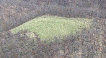
•Landfill Images
•Landfill Monitoring Well Aerial Map
•Landfill Monitoring Well Topo Map
Closure Status:
The landfill closure cap was completed by LCAP in 2011 and is currently in post closure status. Leachate is being trucked to Moundsville Waste Water Treatment Facility for disposal.
Return to the main LCAP page