How It Works
Teams of environmental specialists travel throughout West Virginia's watersheds, sampling streams and
determining their level of impairment.
After a stream is considered impaired and put on the 303(d) list, a TMDL is developed for the stream. The
state is divided into 32 major watersheds,
which are placed into one of five hydrologic groups (hydrologic groups A - E). Each year, DEP personnel
select a watershed(s) from a predetermined
hydrologic group to work in and begin the 4-year process of completing a TMDL. Currently, TMDLs are in
various stages of development for certain
watersheds in Hydrologic Group C, Hydrologic Group D, and Hydrologic Group E.
Why Are TMDLs Necessary?
Public awareness and a desire to control water pollution led to passage of the federal Clean Water Act of
1972. The Clean Water Act established the basis for the
regulation of discharging pollutants into streams. Pollution control programs greatly reduced the amount of
pollutants that went into streams and navigable waters.
Section 303(d) of the Clean Water Act and regulations developed by the U.S. Environmental Protection Agency
(EPA), require states to identify all waters that do
not meet water quality standards even after pollution controls required by law are in place. Waterbodies not
meeting the appropriate water quality standards are
considered to be impaired. The impaired segments identified by the states comprise each state's 303(d) list
(or Section 303(d) list). The 303(d) list of impaired
waters must be submitted to the EPA for review and approval. TMDL's must be developed for all waterbodies on
the approved 303(d) list.
West Virginia has worked diligently with the EPA and many other important stakeholders to assure the completion of
TMDLs.
Choose a watershed below to see completed TMDLs for that watershed. To receive a CD of West Virginia completed
TMDLs, call (304) 926-0495.
Impaired Waters
In a sense, the Water Quality Standards serve as a “measuring stick” to assess the quality of our state’s
waters. Section 303(d) of the Clean Water Act and regulations
developed by the U.S. Environmental Protection Agency (EPA), require states to identify all waters that do
not meet water quality standards
even after pollution controls required by law are in place. Streams or lakes not meeting the appropriate
water quality standards are considered
to be impaired. Every two years, WVDEP publishes a report that contains a list of all streams and lakes in
the state that do not meet Water Quality Standards,
known as the 303(d) list.
For each water listed as impaired by a pollutant, the Clean Water Act then requires that a TMDL be
developed. Full implementation of the TMDL would provide
reasonable assurance that the stream or lake will meet Water Quality Standards to restore the designated
use.
All streams are placed in a category to describe their status relative to assessment, impairment, and water
quality attainment. Category 5
streams are those typically referred to as the “303(d) list”. A few streams are categorized as 4b or 4c and
considered impaired, but do not need a
TMDL. The WVDEP goal is for more waters to be placed in Categories 1 or 2.
| Category |
Description |
| Category 1 |
Waters fully supporting all designated uses. |
| Category 2 |
Waters fully supporting some designated uses, but no or insufficient information exists to assess
the other designated uses. |
| Category 3 |
Water where insufficient or no information exists to determine if any of the uses are being met.
|
| Category 4 |
Waters that are impaired or threatened but do not need a total maximum daily load (TMDL). |
| Category 4a |
Waters that already have an approved TMDL but are still not meeting standards. |
| Category 4b |
Waters that have other control mechanisms in place which are reasonably expected to return the water
to meeting designated uses. |
| Category 4c |
Waters that have been determined to be impaired, but not by a pollutant (e.g. low flow alteration).
|
| Category 5 |
Waters that have been assessed as impaired and are expected to need a TMDL. |
303(d) List Category Description
Pollutants
The map to the right displays impaired waters that need a TMDL and pollutants that have been identified in
the 2016 303(d) list.
Some waters are impaired for multiple pollutants. The color coded layers denote the various pollutants
within the streams.
You can click on a specific section of stream to view the particular pollutants within that section.
Pollution Source Investigation
Pollutant Source Investigations documents sources that cause or contribute to impairment in streams.
Think of a TMDL as a “Pollution Budget.” If a TMDL is being calculated for a stream, we
already know that the stream is impaired because it is receiving too much of a given
pollutant. The question then becomes, what sources of the pollutant load must be
reduced – and by how much.
WVDEP WQSAS gathers available information for the sources of pollution in the watershed.
Typical sources include National Pollutant Discharge Elimination System (NPDES)
permits, abandoned mine lands/discharges, mining permits, logging, pipelines, oil and
gas well drilling, roads, agriculture/pasture, and residential/urban areas.
 This image shows an aerial view of Parkersburg, WV where the Little Kanawha River confluences with
the Ohio River.
Watershed Management Framework
WVDEP has created a Watershed Management Framework through which programs organize efforts on an established
timeline. The TMDL program most often follows
those timelines to assess watersheds and develop TMDLs for streams in an entire watershed to be implemented
by partnering programs. The state is divided
into 32 major USGS HUC8 watersheds, which are placed into one of five hydrologic groups (hydrologic groups A
- E).
Each year, WVDEP personnel select one or more watersheds from a predetermined hydrologic group to begin a
4-year process of completing a TMDL.
At any given time TMDLs can be in various stages of development for as many as 5 Hydrologic Groups.
 Chart of WV Hydrologic Groups
Process For Developing a TMDL
The WVDEP process for developing TMDLs begins with “pre-TMDL” monitoring to collect information about the
streams that are impaired in a watershed.
Multiple sampling stations are selected within the watershed and sampled monthly by WVDEP for one year. The
monthly data are used to assess water quality
and to calibrate a computer model used in the TMDL calculation for each stream.
WVDEP gathers available information for the sources of pollution in the watershed. Typical sources include
NPDES permits, abandoned mine lands/discharges,
mining permits, logging, pipelines, oil and gas well drilling, roads, agriculture/pasture, and
residential/urban areas. Once the pollutant source data are
complete and the computer model is calibrated, the model predicts instream concentrations of the modeled
pollutants (e.g., total iron, dissolved aluminum,
fecal coliform bacteria).
Theoretical reductions can then be made in the computer model to predict how much reduction is needed for a
stream to attain water quality standards.
The percent reduction of the load from different sources of pollution depends upon an allocation approach
established by the WVDEP working with point
and non-point stakeholder communities.
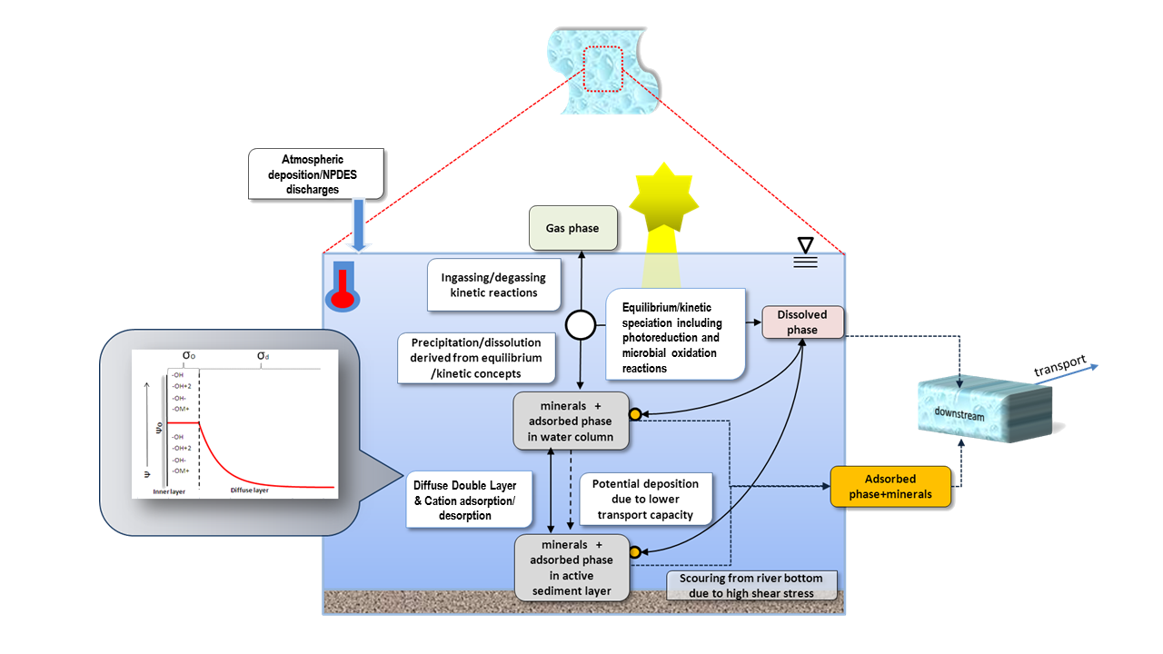
 Stream Representation in Computer Model
Allocation Strategy
The allocation strategy in West Virginia TMDLs takes a “top-down” approach using a computer model to predict
loads from a watershed over different seasons
and flow regimes for a six-year time period. Working from the headwaters "top" of a watershed, the model
tests if load reductions will result in attainment
of water quality standards, then presents a “cumulative load” progressively moving down toward the mouth of
the stream. Once the model demonstrates that
streams meet specific water quality standards, the percent reductions and final TMDL allocations for each
pollutant source result in the final TMDL product.
The TMDLs are described in a TMDL public report and support documentation. After sharing the public report
and addressing comments, WVDEP sends TMDLs to
the USEPA for approval before implementing the TMDLs.
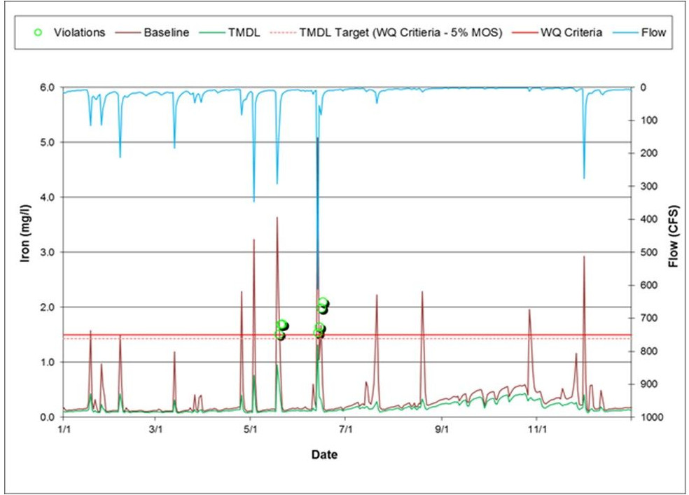
 Baseline and Allocated Model Output